The National Weather Service has issued the following briefing on the potentially heavy rainfall over the weekend as of 7 a.m. EDT Saturday. In summary, there is a threat of heavy rain and a marginal risk for severe thunderstorms.
A frontal boundary will drop over the region this morning and stall out over the Middle Atlantic later today through Sunday. This will allow several rounds of showers and storms to move across the region, possibly allowing for locally excessive rainfall and some flooding. The exact placement of this front will be critical in determining where and when the heaviest rainfall will occur. There is a potential for 1 to 2 inches of rain (with locally higher amounts possible) this weekend across portions of the area. See the attached images for the latest precipitation forecast through Monday morning, as well as the excessive rain outlook and severe weather outlook for Sunday.
The next update on this briefing will be Sunday morning, or earlier if conditions warrant.
Threats and Locations: Heavy Rainfall of 1 to 2 inches. Where the heaviest rain occurs, some flooding is possible. In addition, river flooding is possible starting as early as late Sunday continuing into early next week. Please continue to monitor future forecasts, as we will continue to refine the area with the threat for heavy rain. However, right now the entire region including – Central/South Central Virginia, Tidewater/Eastern Virginia, Hampton Roads, Maryland/Virginia Eastern Shore, and Northeast North Carolina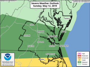 – should prepare for periods of heavy rain and the potential for some localized flooding. There is a marginal risk for severe thunderstorms (except a slight risk along the Albemarle Sound) on Sunday as well, but this risk is highly dependent on where the frontal boundary is located. Currently, our primary concern for this weekend is with locally heavy rainfall.
Timing: The potential exists for heavy rain this afternoon and tonight and Sunday afternoon into Sunday night. Best potential for any strong to severe thunderstorms would be Sunday afternoon into Sunday evening.
Go to the National Weather Service website at https://www.weather.gov/akq/ to stay up to date on the latest information.