By Carol Vaughn —
The third and final public meeting for the Eastern Shore of Virginia Waterways planning project, held virtually in February, focused on progress towards developing a management plan for dredged material in four waterways.
A 2016 regional dredging needs assessment looked at conditions of 52 channels in Accomack and Northampton waterways and identified areas in need of dredging.
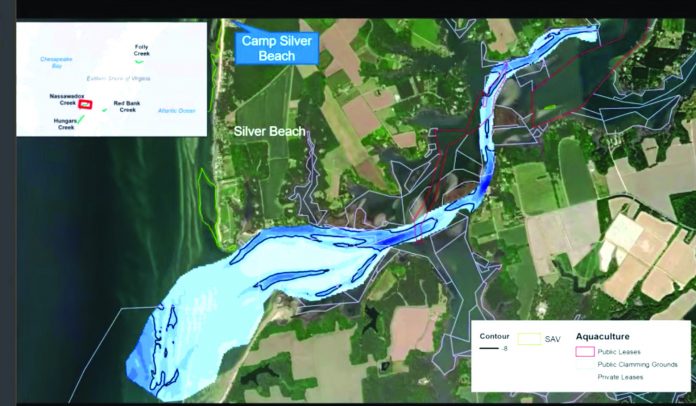
The Accomack-Northampton Planning District Commission received Virginia Port Authority Waterway Maintenance funds for dredged material management planning, with this project focusing on four waterways: Folly Creek, Nassawadox Creek, Red Bank Creek, and Hungars Creek.
The final plan will include the estimated volume of dredged material, sediment composition, potential dredging and construction approaches, potential beneficial uses of the dredged material, and cost analyses.
Beneficial use of the dredged material on the Shore could include marsh enhancement or creation, beach nourishment, or upland uses.
Estimated dredge volume is 20,000 to 65,000 cubic yards for Folly Creek; 15,000 to 35,000 cubic yards for Hungars; 40,000 to 95,000 cubic yards for Nassawadox; and 25,000 to 55,000 cubic yards for Red Bank, according to a presentation at the third meeting.
Sampling showed Folly Creek and Red Bank Creek sediment is mainly silt and clay, while Hungars Creek and Nassawadox Creek sediment is mostly sandy.
Three of the four creeks have no record of previous dredging; Nassawadox Creek was last dredged in 2008 by volunteer recreational boaters from Friends of Nassawadox Creek.
The final plan will prioritize alternatives identified for beneficial use of the dredged material for each creek and will summarize the data collected, public feedback, findings, and recommendations.
Once the plan is completed, Nassawadox Creek will be presented to the Virginia Port Authority for potential permitting and construction.
Future funding will be needed to pay for dredging and to implement recommendations for beneficial use of the dredged material.
Jessica Steelman, ANPDC coastal planner, gave background about the project.
“Why do we dredge? It’s important because we want safe and navigable waterways for the vitality of the Eastern Shore,” she said, noting the Eastern Shore Regional Navigable Waterways Committee was created in 2015 to address the issue.
Ira Brotman, of consulting firm Moffatt & Nichol, spoke about hydrographic survey and sediment sampling results for the four creeks.
“When you dredge you develop sediment volume that you need to do something with. This project is to try to find the most beneficial use of that for different types of projects. … The Eastern Shore has the potential for a lot of different beneficial use,” he said.
Factors to be taken into account when considering where to place dredged material include shellfish leases and aquaculture, seagrass beds, sediment characteristics, ownership and easements, permit conditions, and the proximity of dredging to the placement area, Brotman said.
Preliminarily, two potential areas for marsh enhancement or creation were identified north of the Folly Creek dredging area.
For Red Bank Creek, because of current leases and ownership of adjacent areas, the team found there are not public areas available nearby to place dredged material for marsh creation or enhancement, resulting in the recommendation to do mechanical dredging and look for an upland placement site.
For Hungars Creek, three areas were identified where shoal enhancement could be done using dredged material.
For Nassawadox Creek, four areas for potential beach nourishment or shoal enhancement were identified.
A public survey about the project, completed last summer, resulted in 2,561 website views and 21,058 social media views, resulting in 97 participants, 812 responses, and 274 comments.
Among the results were: for 87% of respondents, their main concern when navigating the creeks is shallow water depth; 64% said Nassawadox Creek is the most challenging of the four to navigate; 51% said Nassawadox Creek is the creek they use most frequently; 47% said they use the creek or creeks more than once a week; 90% use the creeks for recreation; and 92% use a motor boat to travel the creeks.
Of those who responded, 75% were male and 42% were age 65 or older.
Information about the project is at https://www.publicinput.com/P1564#


